BC's NTS Coordinates Explained
What are NTS Coordinates?
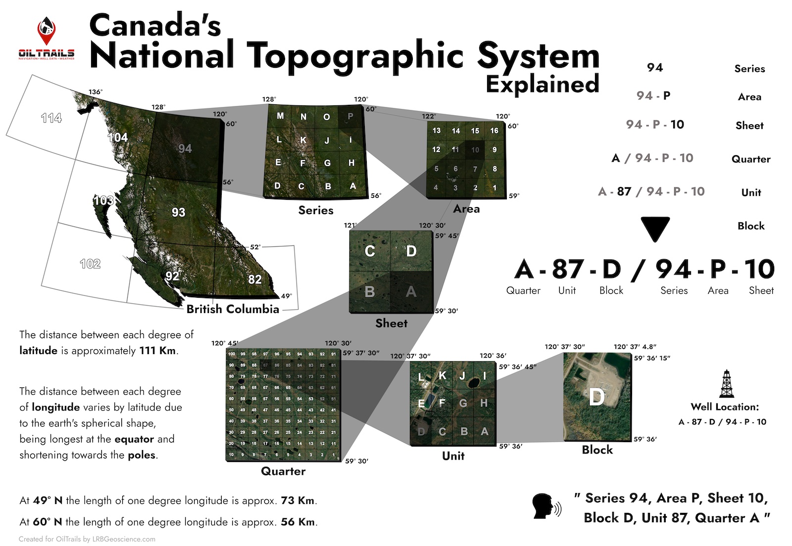
Understanding Canada's National Topographic System (NTS) coordinate system is essential for locating oil and gas wells in the Northern BC. The NTS system provides a standardized and precise way of mapping and navigating through the vast and often remote wilderness of northern BC. In this article, we will define and describe the different components of the NTS coordinate system - Series, Area, Sheet, Quarter, Unit, and Block - and how they relate to finding oil and gas wells in this region.

An NTS coordinate consists of a Series, Area, Sheet, Quarter, Unit and Block
Series
The NTS is divided into several series, each covering a specific region of Canada. The most commonly used series in northern BC for oil and gas exploration and production are the 1:50,000 and 1:250,000 scales. The 1:50,000 scale series is used for detailed mapping of a specific area, while the 1:250,000 scale series is used for broader mapping of larger areas.
Area
Each series is further divided into areas, identified by a two-letter code. These codes are based on the name of a prominent feature within the area, such as a mountain or lake. In northern BC, the area codes can be identified on topographic maps. They are used as a reference to locate specific regions where oil and gas wells may be located.
Sheet
Each area is divided into sheets, which are identified by a number and letter code. The number represents the east-west location of the sheet within the area, while the letter represents the north-south location. For example, the sheet code "94P12" represents the twelfth sheet in the "94P" area of northern BC.
Quarter
Each sheet is divided into four quarters, each with its own unique code. These codes are based on the location of the quarter within the sheet, with the top-left quarter being "a," the top-right quarter being "b," the bottom-left quarter being "c," and the bottom-right quarter being "d." These quarter codes are used to further pinpoint the location of oil and gas wells within a specific sheet.
Unit
Each quarter is further divided into units, each with its own unique code. These codes are based on the location of the unit within the quarter, with the top-left unit being "1," the top-right unit being "2," the bottom-left unit being "3," and the bottom-right unit being "4." These unit codes are used to further refine the location of oil and gas wells within a specific quarter.
Block
Finally, each unit is divided into blocks, each with its own unique code. These codes are based on the location of the block within the unit, with the top-left block being "a," the top-right block being "b," the bottom-left block being "c," and the bottom-right block being "d." These block codes are used to pinpoint the exact location of oil and gas wells within a specific unit.
Conclusion
Using the NTS coordinate system, oil and gas workers in northern BC can precisely locate and navigate to specific areas, sheets, quarters, units, and blocks on topographic maps. This is crucial for conducting field surveys, accessing well sites, and identifying potential drilling locations. Additionally, the NTS system allows for accurate communication and record-keeping of well locations, which is essential for regulatory compliance and efficient operations in the oil and gas industry.
An effective tool for easily locating these wells is the OilTrails mobile app. OilTrails is a mobile app that allows oil and gas workers to easily locate and navigate to oil and gas wells in northern BC. The app uses the NTS coordinate system to give directions to NTS coordinates, and also allows users to save and share well locations with other workers. OilTrails is available for download on the App Store and Google Play.