The Evolution of Grid Mapping in Oil & Gas
From Paper Maps to Up-To-Date Satellite Imagery
January 31, 2025
Grid mapping in the oil and gas industry has come a long way. It started with paper maps, highlighters, and manual updates. Today, we have digital solutions with GPS, real-time data, and satellite imagery. If you’re still using static maps, it’s time to see how modern grid mapping can improve efficiency.
Let’s explore how mapping technology has evolved and why OilTrails, using Mapbox’s mapping technology, is leading the way in smarter, more reliable oilfield mapping.
From Paper to Digital – The Tech Revolution in Mapping
Not long ago, oilfield operators and landmen relied on large binders filled with paper grid maps. These maps were hard to update, easy to misplace, and quickly became outdated. If a new well was drilled or a lease boundary changed, someone had to mark it manually.
Now, digital mapping has taken over. With GIS (Geographic Information Systems) and cloud-based platforms, teams can access up-to-date maps from any device, whether in the office or the field. Digital grid maps reduce errors, improve decision-making, and allow teams to collaborate in real time.
One of the leaders in this space is Mapbox. Their high-performance mapping tools power industries worldwide, offering custom styling, vector maps, and smooth integration with live data. OilTrails integrates Mapbox’s powerful mapping technology, customizing it to meet the unique challenges of the Canadian oilfield. It includes high-resolution 3D satellite imagery, in app navigation, and offline access.
➡ Want to learn more about GIS? Check out Wikipedia’s guide to Geographic Information Systems.
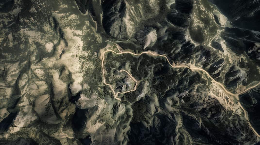
Satellite Integration – The Evolution of 3D & High-Res Grid Mapping
Satellite imagery has advanced far beyond the blurry, low-resolution images of the past. Today, high-resolution, 3D satellite maps allow oil and gas professionals to see lease roads, well pads, and access routes—even when they’re not on traditional maps.
New imaging techniques help capture terrain with more precision than ever. Many modern satellites use synthetic aperture radar (SAR) and optical imaging. These systems collect multiple angles of the same location, creating accurate 3D models of oilfield areas. Some companies also use LiDAR (Light Detection and Ranging), which scans the land using aircraft or drones. This technology detects elevation changes and updates mapping data continuously.
With Mapbox’s satellite imagery and 3D mapping, OilTrails users get a clear, interactive view of oilfield operations. Even in remote areas with no government road data, the latest maps show lease roads, well access points, and terrain features. This reduces navigation errors, unexpected delays, and safety risks.
Up-to-Date Mapping – Why Static Maps Are a Thing of the Past
Still using static PDF maps or printouts? You’re missing out on the biggest advancement in oilfield mapping—continuous updates. Modern grid maps don’t just show the land. They update continuously to reflect new wells and lease changes.
Along with live weather updates, you can check lease-specific forecasts in real time. Instead of guessing if snow, rain, or wind will affect travel, you can see the lease conditions before heading out. This is especially valuable in remote areas, where conditions can change fast.
Satellite maps also update constantly. New roads, infrastructure, and drilling sites appear in mapping systems weeks before they’re visible on standard navigation platforms. This means you get the most current field-ready data instead of relying on outdated maps.
OilTrails brings these features to oilfield professionals with constantly updated mapping, well data integration, and lease-specific weather. Want to see it in action? Check out our LSD Finder, a free tool for locating Legal Subdivisions (LSDs) using live mapping technology.
➡ Try it now at OilTrails.ca/navigation (desktop only) or download the Mobile Version.
OilTrails + Mapbox: Mapping Built for the Canadian Oilfield
At OilTrails, we know that oilfield professionals need accurate, up-to-date maps. That’s why we built our mapping system using Mapbox’s industry-leading technology. Whether you need detailed grid maps, well tracking, or offline access, OilTrails delivers reliable, up-to-date navigation for field operations.
With live weather integration, advanced search tools, and lease tracking, OilTrails isn’t just a map—it’s your oilfield intelligence system. No more flipping through old binders or struggling with outdated navigation. Your grid map is always updated, always available, and built for real-world operations.
Upgrade your mapping system today!
➡ Download OilTrails on the App Store
➡ Get OilTrails on Google Play
➡ OilTrails Pro Pricing Built for Teams
Final Thoughts
The days of paper maps and manual updates are over. Modern grid mapping, real-time satellite data, and live updates give oil and gas professionals the tools they need to navigate smarter and safer. Whether you’re managing a drilling site, tracking well performance, or planning access routes, today’s mapping technology helps keep you one step ahead.
➡ Want to learn more? Explore our guides on:
📌 Alberta LSD Locations
📌 BC NTS Locations
Have questions about oilfield mapping? Contact us—we’d love to hear from you!