GeoPics for Android Is Here: Rebuilt and Free on Google Play
GeoPics has been rebuilt inside OilTrails and released as a free standalone Android app for capturing, organizing, and sharing location-stamped photos.
September 1, 2026
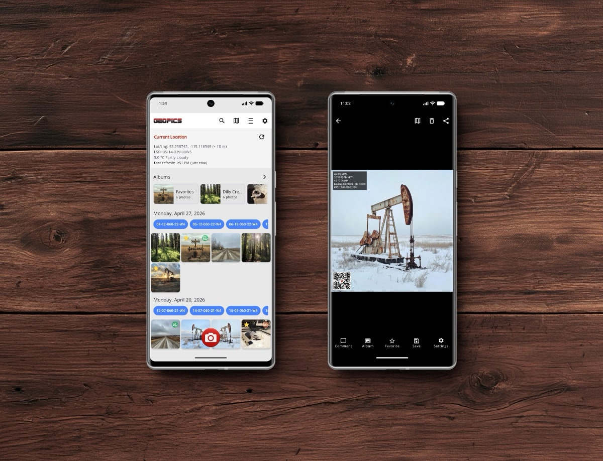
A photo of a lease-road approach might be useful when it is taken, but its value drops quickly if the next person cannot tell where it came from, when it was taken, or what they should notice.
GeoPics is built to keep those details with the image. It can add the photo’s coordinates, elevation, available weather and Canadian legal land descriptions, date, time, comments, and a location QR code to the finished image. Field staff can document a wellsite, gate, sign, piece of equipment, or access issue, then save or share a photo that carries its own location details.
We have completely rebuilt GeoPics for Android inside OilTrails. We have also released it as a separate Android app that is free to download and use, with no account or subscription required.
Download GeoPics for Android on Google Play.
An OilTrails User Suggestion That Kept Growing
GeoPics began with a suggestion from an OilTrails user who wanted a better way to keep location information with field photos.
That request first became a feature inside OilTrails. As more people used it, the idea grew beyond adding a stamp to a picture. Users needed a dependable camera, an organized photo library, comments, batch tools, maps, and a clearer way to move photos from the field to the people who needed them.
The new Android release is the next step in that history. GeoPics is still part of OilTrails, but it now has a faster and more dependable foundation. The same rebuilt experience is also available in the standalone GeoPics app for anyone who wants location-stamped photos without an OilTrails account.
Capture the Details That Matter at the Site
The new camera is designed for taking more than one quick photo and getting back to the job. You can capture several GeoPics in one session, switch cameras, control the flash, zoom, choose the capture quality, use a volume button as the shutter, and see clearer feedback while each photo is being processed.
Before opening the camera, GeoPics shows the current location, accuracy, freshness, coordinates, available weather, and any available LSD and NTS results. This gives the person taking the photo a chance to confirm the information before capturing it.
Give the Office More Than a Photo
A useful field photo identifies the place and time, then explains what the viewer should notice.
GeoPics can place available GPS coordinates, elevation, weather, LSD, NTS, UTM, date, time, and a field comment directly on the exported image. The person taking the photos can add a note to one GeoPic, apply the same comment to several selected photos, or add one comment to every photo from a camera session.
A dispatcher can confirm which approach a driver photographed before assigning a return trip. A supervisor can review a gate, sign, equipment issue, or lease-road concern without asking the field worker to resend the image and explain where it was taken. The photo can be saved to the device or shared through a compatible app without requiring the recipient to open GeoPics.
Find the Photo Again
The rebuilt Gallery groups GeoPics by date and shows clearer thumbnails, weekday labels, location details, Favorites, Albums, and export status. Search can look through GeoPic details, while exact legal-location filters can narrow a large Gallery to the site you need.
GeoPics can also place located photos on an interactive map. Open the full map to review where photos were taken, or open a focused map from one GeoPic when you need to return to that location or pass it to another mapping app.
Local Albums and Favorites are available in the standalone app and in OilTrails. They make it easier to group photos around a job, area, customer, or follow-up without changing the original photo.
Know Which Copy You Shared
A comment or overlay can change after a GeoPic has already been saved to the device. The new export indicators show whether the current version has been saved or whether it has changed since the last export.
GeoPics also warns before saving another copy of the same version. When several photos are selected, you can save or share them together and follow the operation’s progress. Exported images can optionally be placed in a dedicated GeoPics Photos album on the device.
This helps field staff avoid duplicate copies and helps the office receive the version that includes the latest comment or location display.
More Control Over the Finished Image
Different jobs call for different information. GeoPics lets you choose which metadata fields appear, change their order, adjust the overlay size, and select text and background colours. You can choose the date format, use 12-hour or 24-hour time, and add a QR code that opens the photo location on a map.
The original photo remains in the GeoPics library while the finished version is rendered when you save or share it. That means you can correct a comment or change the overlay without taking the photo again.
Built Into OilTrails, or Free on Its Own
The standalone GeoPics app keeps its photo library on the Android device. It does not require an OilTrails account or subscription, and its photos are not uploaded to OilTrails cloud storage.
Inside OilTrails, signed-in users can also add GeoPics to cloud Collections. This lets field users upload selected photos, keep them with other job information, and make them available for later review. Local device storage, cloud storage, and Collection membership remain separate, so removing a photo from one place does not silently delete every copy.
More Improvements in GeoPics for Android
- A redesigned Photo Viewer with portrait and landscape support, swipe navigation, panning, and zoom up to 8×
- Multi-photo actions for comments, Albums, Collections in OilTrails, saving, sharing, and deletion
- Normal and Hybrid photo maps with the selected map style remembered
- One-photo and Gallery map views with thumbnail markers and clustered counts
- Separate camera capture quality and export quality settings
- Clearer handling for low storage, missing originals, damaged thumbnails, interrupted camera access, and unavailable location details
- Safeguards for users moving from the original GeoPics workspace into GeoPics V2
- Improved Canadian results that preserve available LSD and NTS location information
- More privacy-conscious diagnostics that exclude GeoPic coordinates and diagnostic location details
- Updated dark-mode colours, phone and tablet layouts, launcher artwork, splash artwork, and controls
Download GeoPics and Tell Us What You Think
One user’s suggestion became an OilTrails feature, a complete rebuild, and now a free standalone Android app. We are excited to see how drivers, field staff, dispatchers, supervisors, and office teams use it.
Download GeoPics free from Google Play, take it to the field, and let us know what you think. Your feedback will help decide what we improve next.